 Tweet
Tweet
(I debated putting this in the TrailRun or Tech forums, but decided that if the Places to Wheel thread can go here, so can this. PTB can move it if they want...)
I was always ashamed to admit just how completely lost I got at Haspin, even after years of wheeling out there. Too many twists n turns, too many crisscrossing trails, and too much really similar-looking terrain. I had looked for a decent map online and came up empty.
So I've been playing around with my new offroading GPS app, BackCountry Navigator (www.backcountrynavigator.com). The trial was free, the "PRO" version was only $10-15. I've been THRILLED with it...
Anyway, this isn't plug for BCN.
We covered a lot of ground following Jimmy (Runoveru2) on the club trip on the 10th, and I used the track recording to generate a very simple map:
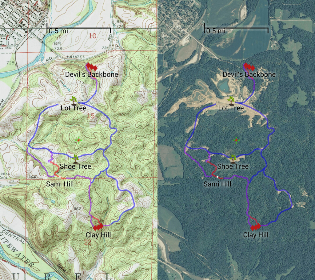
It's loosely color-coded so that:
Blue - Fire Roads, tow-rig passable
Purple - Basic Trails, open-diff passable
Red - Moderate Hills, lockers helpful
Red Diamonds - Challenging Hills, lockers almost required.
Again, it was very basic, and I didn't bother to trace more than a quarter of the trails we ran. I figured (A) if you plot every trail at Haspin, it'll look like a bowl of spaghetti. And (B) this was enough to get a feel for the layout of the park, and help you get around. Especially in a "We gotta get a busted rig out of here as easily as possible" situation. (Which, coincidentally, we did...)
I was always ashamed to admit just how completely lost I got at Haspin, even after years of wheeling out there. Too many twists n turns, too many crisscrossing trails, and too much really similar-looking terrain. I had looked for a decent map online and came up empty.
So I've been playing around with my new offroading GPS app, BackCountry Navigator (www.backcountrynavigator.com). The trial was free, the "PRO" version was only $10-15. I've been THRILLED with it...
Anyway, this isn't plug for BCN.
We covered a lot of ground following Jimmy (Runoveru2) on the club trip on the 10th, and I used the track recording to generate a very simple map:
It's loosely color-coded so that:
Blue - Fire Roads, tow-rig passable
Purple - Basic Trails, open-diff passable
Red - Moderate Hills, lockers helpful
Red Diamonds - Challenging Hills, lockers almost required.
Again, it was very basic, and I didn't bother to trace more than a quarter of the trails we ran. I figured (A) if you plot every trail at Haspin, it'll look like a bowl of spaghetti. And (B) this was enough to get a feel for the layout of the park, and help you get around. Especially in a "We gotta get a busted rig out of here as easily as possible" situation. (Which, coincidentally, we did...)

Comment